

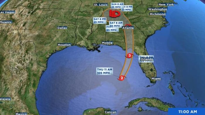
ORLANDO, Fla. – Hurricane Helene is strengthening in the Gulf of Mexico before becoming a major hurricane and striking the Big Bend area of Florida, according to the National Hurricane Center.
Helene is forecast to rapidly intensify and grow into a major Category 3 hurricane as it makes landfall between Panama City and Cedar Key Thursday evening.
[RELATED: COUNTY-BY-COUNTY impacts | Timing of Helene in Central Florida | Here’s what the ‘dirty side’ of a storm means | DOWNLOAD: WKMG-TV free hurricane app]
As of the 5 a.m. update, Helene had maximum sustained winds of 90 mph and was moving north-northeast at 12 mph. It is about 350 miles southwest of Tampa.
The latest forecast no longer shows Helene reaching Category 4 status but it is still expected to reach Category 3 strength later on Thursday.
Here is what determines each category for a hurricane:
-
Category 1 — 74 to 95 mph sustained winds
-
Category 2 — 96 to 110 mph sustained winds
-
Category 3 — 111 to 129 mph sustained winds
-
Category 4 — 130 to 156 mph sustained winds
-
Category 5 — 157 mph or higher sustained winds
The center of Helene will move across the eastern Gulf of Mexico Thursday and cross the Big Bend coast Thursday evening or early Friday morning.
Not only is Helene forecast to quickly strengthen, but it’s also expected to grow in size with tropical storm winds extending more than 345 miles out from its center. Tropical storm force wind gusts (30-65 mph) will be possible for the majority of Central Florida by Thursday.
The worst of the weather from Hurricane Helene will take place in the Big Bend, Panhandle region of Florida. As the storm lifts through the Gulf of Mexico, outer bands from Helene will move onshore and push through Central Florida.
[TIMELINE: Here’s when Hurricane Helene will impact Central Florida]
Watches and warnings have been issued for parts of Florida ahead of the projected major hurricane.
Gov. Ron DeSantis on Monday declared a state of emergency for 61 counties, including all of Central Florida.
Since 2000, eight major hurricanes have made landfall in Florida, according to Philip Klotzbach, a Colorado State University hurricane researcher.
In the Atlantic
Tropical Storm Isaac formed Wednesday night in the open central Atlantic.
It could become a hurricane in the next couple of days as it heads east.
In the eastern and central tropical Atlantic, Invest 98L could become a tropical depression in the next day or two as it moves west.
It has a 70% chance of development in the next 48 hours and an 80% chance of development in the next seven days.
Hurricane season runs through November.
The Associated Press contributed to this report.
Meteorologist Jonathan Kegges provides the latest information about everything happening in the tropics.
Get today’s headlines in minutes with Your Florida Daily:


Post comments (0)